Summary of the 2004 Excavation Season
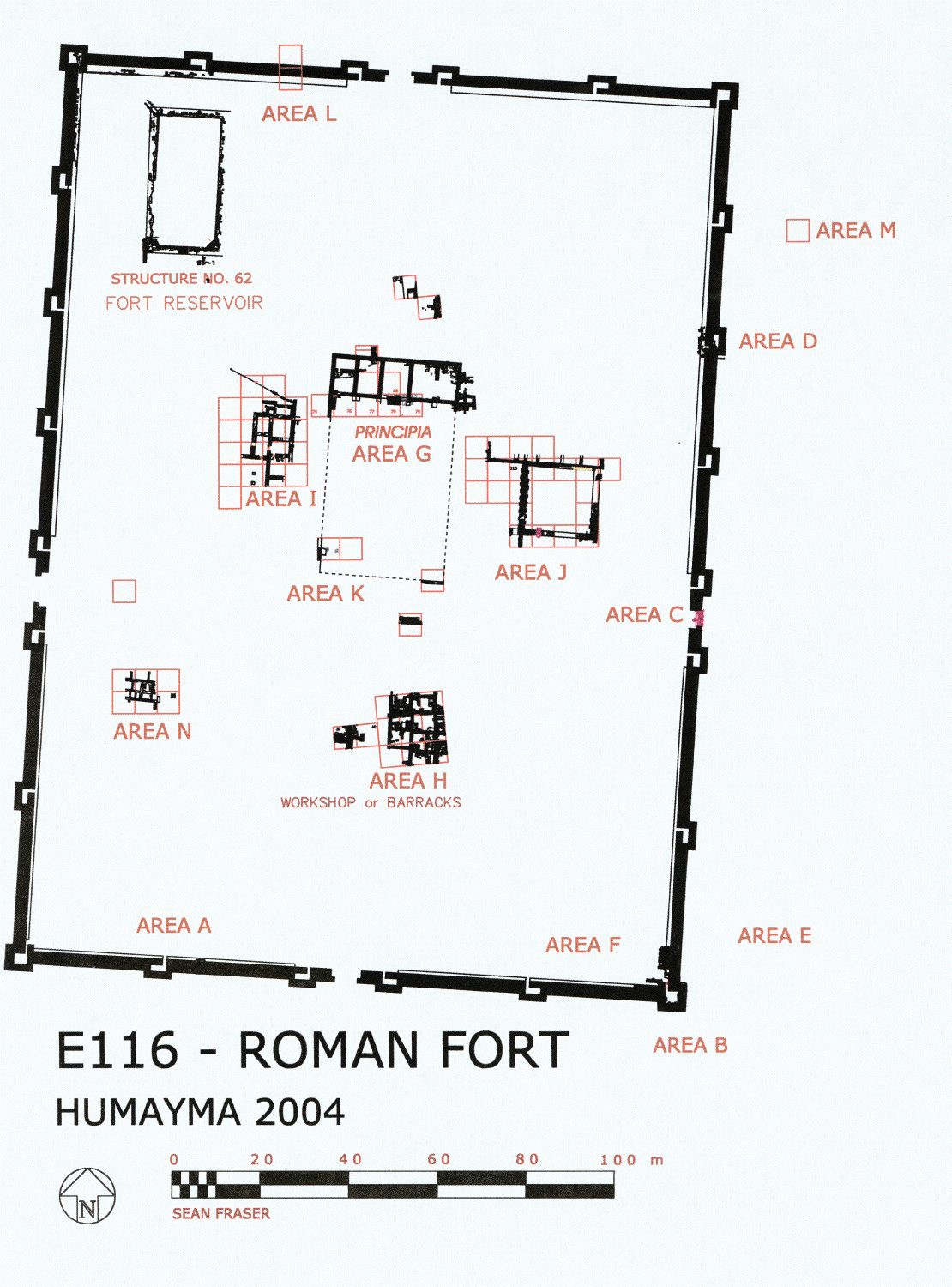
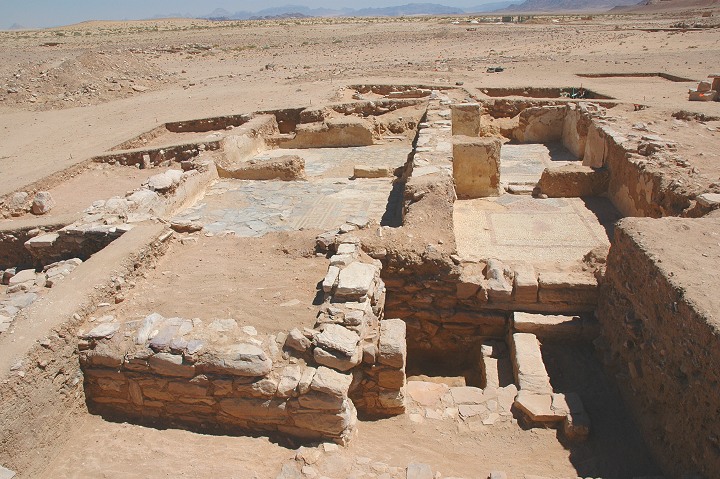
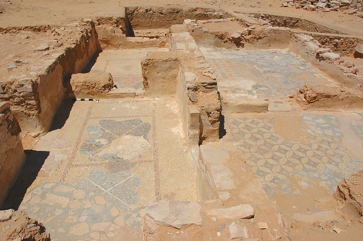
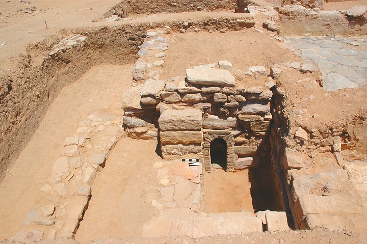
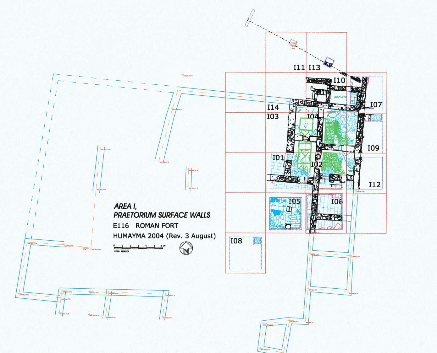
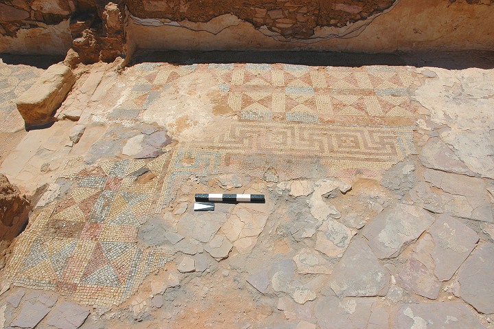
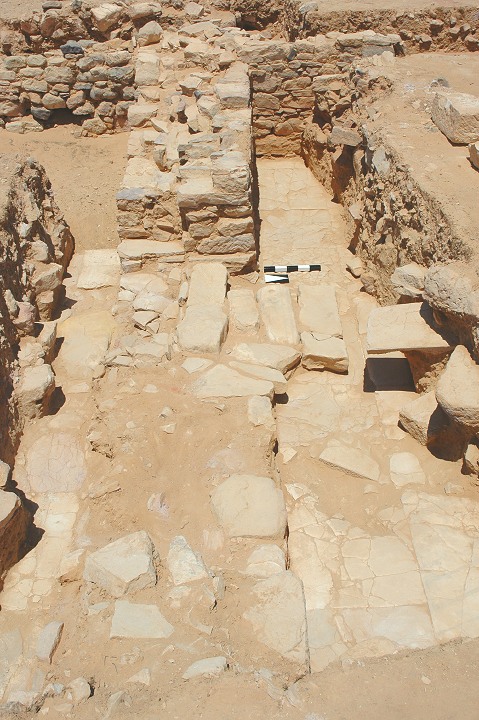
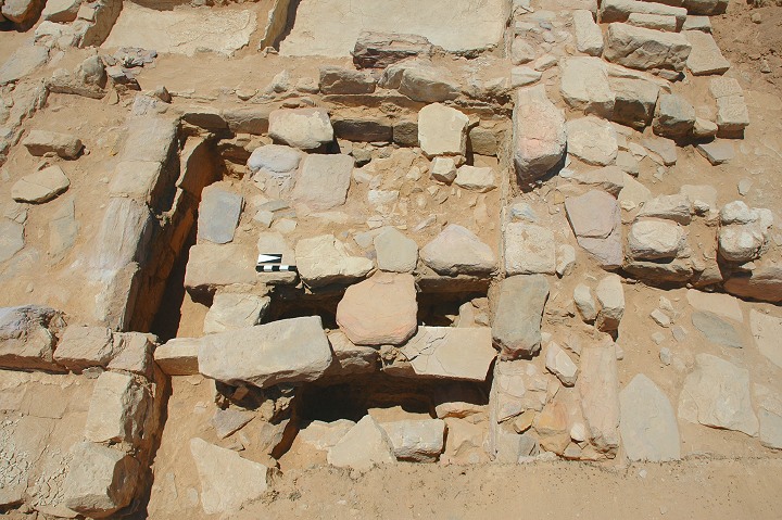
The ninth season of the Humayma Excavation Project took place from 19 June through 29 July 2004. Excavation focused on the Roman fort and the community located outside its main gate (plan of fort). The residence of the commander in the Roman fort (the Praetorium), with elaborate mosaic floors, was identified in 2000. This year we cleared in their entirety several of these rooms (general view), the largest of which proved to have a central mosaic panel surrounded by flagstone paving (view of mosaic). This room, possibly intended for communal banquets or receptions, was associated with a small heated bathing room. A small arch provided access to the furnace that heated the suspended floor (view of bath). The Praetorium included a large number of smaller rooms (still to be excavated) arranged in part around a paved, colonnaded courtyard (plan).
At some point significant damage was inflicted on the mosaic floor, and the evidence for careless but extensive repairs pose new questions (repaired floor). How was the mosaic damaged in the first place? Did the building suffer earthquake damage, or does the damage represent intentional vandalism carried out by a hostile force that occupied the fort at some point prior to its abandonment during the reign of Diocletian. The damage may also have resulted from simple neglect of the building during the period of abandonment. The same questions can be asked about the thorough destruction of the hypocaust. At any rate, early in the fourth century, either civilian squatters or a military unit repaired the floors of the Praetorium, filled the hypocaust room with rubbish, and reoccupied the structure. Given the relatively small amount of roof tile recovered from the building, it is likely that the rooftiles were salvaged at the end of the third century, before the reoccupation, and taken elsewhere for reuse.
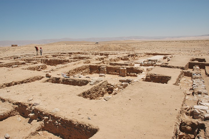
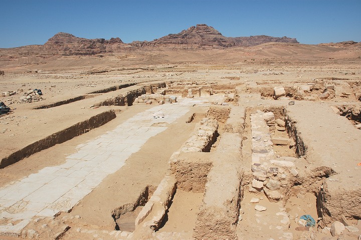
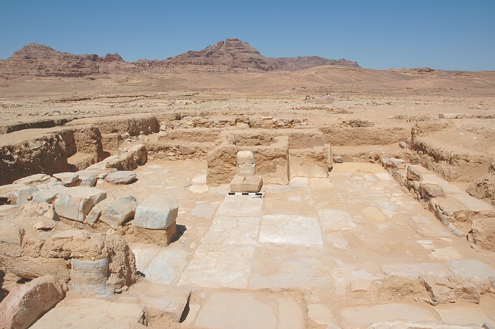
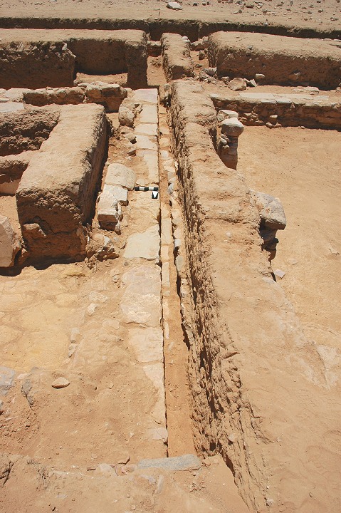
Results from the 2004 excavation season have strengthened the case for identifying the large structure in Area J as the fort's granary (Horreum)(Area J). Granaries are commonly located in the central range on one side or the other of the Principia courtyard, where easy access is provided from the main east-west road. They are often paired, and stone granaries can be double-sized and share a common central wall as seen at the Saalburg in Germany and Benwell in England, and also at Humayma (central wall). Granaries normally have substantial longitudinal walls like the Area J building, often with external buttresses (view of entrance). Not all granaries had raised floors, and stone-built granaries can have floors laid directly on the ground without provision for ventilation, as in our structure. Columella in fact describes a vaulted granary with plastered walls and a floor consisting of packed earth mixed with oil lees and covered with tiles set in a lime mortar mixed with oil lees, which may be represented by Room A (Columella 1.6.9). Carefully mortared stone or tile floors and plastered thick stone walls would help to keep grain cool and free from insect infestation, as well as provide a cool environment for the storage of other foodstuffs. The absence of evidence for re-use of the granary for its original purpose during the fourth-century reoccupation of the fort constitutes further evidence that the second phase of occupation of the fort was much less extensive and well organized than the original phase.
In 2004 a beginning was made on an extensive survey of the water-supply system in the fort. Although it has not yet been determined how water was moved from the reservoir into the water system, significant remains of piping installations and water conduits were uncovered, along with a well-constructed latrine. The latrine is a solidly built rectangular structure with a central paved area surrounded by a drainage ditch (Area N; latrine view). The ditch may have been used as a squat trench, or wooden seats, now lost, may have been built over it. The ditch was fed with water from a large terracotta pipe in the north wall of the building, oriented upwards to the water source. The water flowed around three sides of the paved area and out a drain that probably led to the drain beneath the main north/south road in the fort. Since the water intake pipe in the latrine is located nearly at the same level as the top of the fort reservoir, the latrine have been served by a small-scale elevated aqueduct system that extended through higher areas within the fort. Water-lifting devices such as the shaduf or the wheel with compartmented rim may have been used to lift water to an elevated reservoir serving this water system.
Outside the fort, our investigations of the Roman period settlement continued in 2004 to focus on Field E125, where a large mudbrick structure is slowly being exposed. This structure is particularly interesting because it incorporates several discrete living and working areas, and a shrine patronized by both Roman soldiers and civilians. (E125 plan, E125 view). The complex was built in the late-2nd century or early-3rd century AD, was crudely renovated in the mid-3rd century, and temporarily occupied by squatters in the early-4th century. In its initial phase, the building was well-constructed and had polychrome figural and geometric frescoes decorating its walls, including the walls of the shrine. A 20 m long paved processional way was uncovered this year, leading from a gate directly west to the shrine area (processional way, shrine), and providing an excellent view of the Jebel Qalkha that looms over the site. The orientation of the shrine may have been governed by feelings of reverence for the jebel, which figures in the Nabataean foundation myth of Hawara.
The processional way and the extant shrine seem to date to the Roman phase of occupation, but beneath the Roman building were discovered the robbed-out walls of another impressive building, this one dating to the Nabataean era (Nabataean wall). Although we have always known that the Nabataeans built a permanent settlement at Humayma and although the stones from their buildings can be seen in re-used contexts throughout the fort, previous attempts to locate the Nabataean settlement of Hawara have been in vain. The presence of finely constructed Nabataean stone walls beneath both the Roman residential complex and the adjacent Roman bath-building, however, suggests that the public buildings of Nabataean Hawara were probably located in this area. The fact that the walls of each building were robbed-out and then used as a foundation of a Roman building may mean the transition from Nabataean to Roman rule here was not peaceful, and involved the destruction of much of the Nabataean settlement.
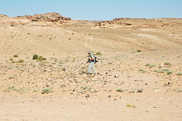
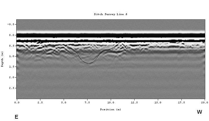
The 2004 field season at Humayma included collection of geophysical data within and surrounding the Roman Fort. Tools used include ground penetrating radar (GPR) and magnetic gradiometry (Baker with magnetometer). Some areas previously surveyed in 2002 were re-surveyed with a finer scale to provide more details, and new areas were examined to test hypotheses and potentially locate unknown features. Eleven zones of geophysical data were collected—ranging from small zones used to locate hydraulic features associated with the Fort reservoir to very large zones used in an attempt to locate a potential kiln site. The geophysical survey proved very effective in revealing the plans of structures known but not yet excavated, and revealing the presence of structures and other features still hidden in the ground. One spectacular discovery was the presence of an unsuspected defensive trench around the Roman fort, a very rare example of such a type of defense in the Roman Near East (trench profile).
Humayma continues to be a fruitful and exciting archaeological site. The Canadian team will return in 2005 to continue excavation in the Roman fort and the shrine complex.
The project director was Prof. John P. Oleson of the Department of Greek and Roman Studies, University of Victoria. Andrew N. Sherwood of the University of Guelph was co-director, M. Barbara Reeves of Queen’s University, and Erik de Bruijn of the University of British Columbia were Assistant Directors. Gregory S. Baker of the University of Buffalo was Director of the Geophysical Survey, assisted by Heather Ambrose and Scott Gagliardi. Ms. Manal Basyouni served as the Representative of the Department of Antiquities to the project. The bulk of the funding was once again provided by the Social Sciences and Humanities Research Council of Canada and the Taggart Foundation, while the National Science Foundation (USA) provided funding to help pay for the costs of the geophysical survey. The Humayma Excavation Project is accredited by the Archaeological Standards Committee of the American Schools of Oriental Research and licensed by the Department of Antiquities of the Kingdom of Jordan. The Project Director is very grateful to Dr. Fawwaz al-Khraysheh, Director General of the Department of Antiquities, for his assistance with the project, and to Dr. Pierre Bikai, Director of ACOR for his help with the practical arrangements necessary for carrying out the season’s work. Accommodations for the team were once again generously provided at the Prince Hashem School al-Mureighah, courtesy of the Headmaster Lt. Col. Suleiman al-Jazi.