THE HISTORY AND GOALS OF THE HUMAYMA EXCAVATION PROJECT
1. Brief History of the Project, and Plans for the Future.
2. Project Objectives.
3. Scholarly Context and Background of Project.
4. Proposed Geophysical Survey and Excavation of the Fort and Vicus, 2002-4.
5. The Excavation and Research Team.
6. Bibliography Relevant to the Project
1. Brief History of the Project, and Plans for the Future.
This presentation is written for the most part in the first person, by J.P. Oleson, but the information presented here is based on the hard work of my co-directors of various years (Dr. Khairieh 'Amr, Dr. Rebecca Foote, Dr. Robert Schick), assistant directors (Erik de Bruijn, Barbara Reeves, Dr. Andrew Sherwood), technical staff, North American volunteers, and Bedouin workers. I am grateful to all of them for their involvement in the project over so many years.
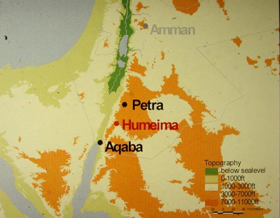
Ancient Hawara (locator map), modern Humayma (or "Humeima", the official Jordanian spelling has changed recently), was a small trading post and caravan way-station in Edom, the desert region of southern Jordan (aerial view). It was founded by the Nabataean King Aretas III in the 80s B.C. to serve as a centre for sedentarization of the local nomadic Nabataean pastoralists at a time when regional trade routes were shifting elsewhere, and as a strategy of state formation by a developing monarchy. Through careful management of the meager spring water and precipitation, the community was able to enjoy a settled existence based on agriculture, stock-raising, and passing caravans. Soon after the Roman conquest of the Nabataean kingdom in A.D. 106 and formation of the Provincia Arabia, Trajan's forces built a major fort at the site to administer this region and suppress any local resistance. A modest prosperity continued through the Byzantine, and early Islamic periods, until the site was abandoned around 750 A.C.
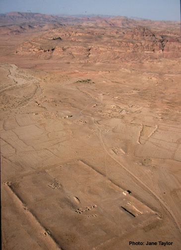
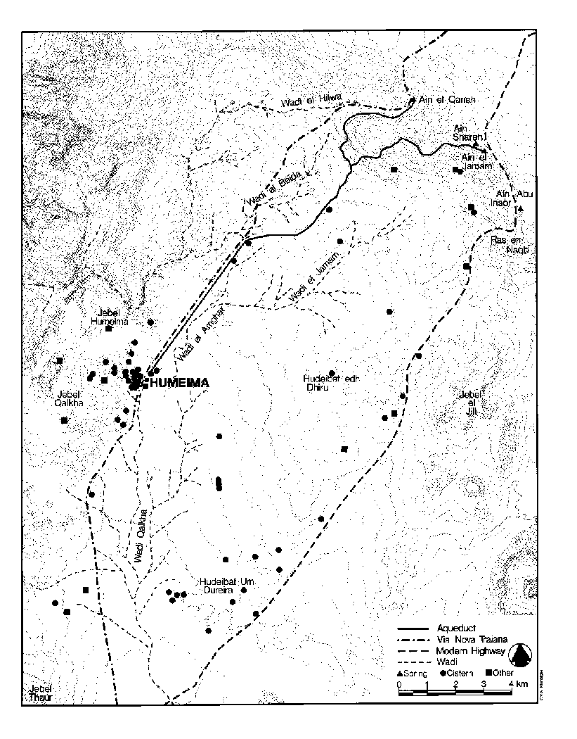
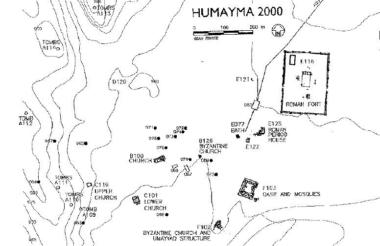
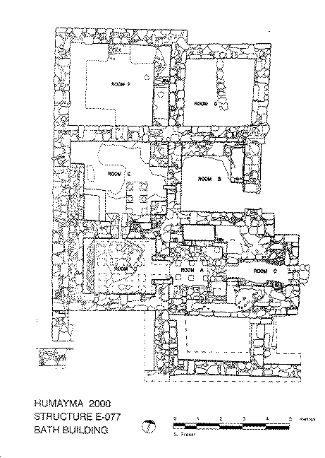
I surveyed and probed the water-supply system in the settlement centre and surrounding region between 1986 and 1989 as an exploration of cultural responses to a desert environment (regional survey map). The continuity of occupation at Humayma across several critical historical periods, the impressive architectural remains, and the absence of modern occupation at the site led me to undertake excavation of the settlement centre in seven field seasons between 1991 and 2000 (site plan). Over this period my team excavated a Nabataean campground and three Nabataean and Late Roman houses, began excavation of the Roman fort and excavated the bath completely, excavated and probed four Byzantine churches, excavated and consolidated a fifth church, and excavated two Umayyad-Abbasid farmhouses. We also excavated the large, early Abbasid qasr (fortified house) and mosque that served as the residence of the famous Abbasid family. Finally, we have probed miscellaneous structures within the settlement centre and sampled many of the partly plundered rock-cut tombs surrounding it. We also consolidated the bath building, one church, the mosque, portions of the fort, and generally cleaned up the site for tourism.
Although large areas of the site remain unexcavated, we now have an excellent understanding of the stratigraphic sequence, a detailed database and typology of the ceramics, and excellent documentation of occupation areas and structures from every period of Hawara's history. The results of the last two field seasons have been particularly fruitful, fulfilling the major planning goals. We have developed a basic plan of some of the major structures in the Roman fort, which yielded rich deposits of occupation debris, frescoes, and a Praetorium paved with colourful mosaics, the first mosaic found south of Petra. Nearby we have excavated several houses in the vicus (the civilian settlement associated with a fort), built of mud brick and stone, decorated with figured frescoes, and filled with a variety of well-preserved artifacts, and a shrine with inscribed altar that identifies the legionary detachment stationed at the fort. Excavation of the Abbasid qasr has been completed, and conservation of the remarkable frescoes and carved ivory furniture continues.
The continued investigation at Humayma will focus on the fort, which archaeologists now agree is one of the most important sites for understanding the character of the Roman occupation of Jordan and the nature of the eastern frontier. We will continue to sample enough areas of the large Roman fort to enable us to draw a complete plan of its interior blocks and major structures, and to define the functions assigned to the various quadrants and blocks. A geophysical survey will help to define the plan of the fort and to reveal the extent of the vicus, which will be probed as well. I also need to clarify the plan of the military bath by means of a trench at its south end and probe a pottery kiln found in 2000. I plan a study session in 2002 to allow completion of final reports on previous seasons and to carry out the geophysical survey, and excavation seasons in 2003 and 2004.
This research will fill some important gaps in our knowledge of the administration of the province of Arabia during the early years of its formation and the character of the eastern frontier of the Roman empire, the frontier most critical to imperial administration from the second to the fifth century A.C. The typology and database of local and regional ceramics of the Roman and Byzantine periods will be further expanded, including the products of the local kiln serving the Roman fort.
2. Project Objectives.
The ultimate objective of this stage of the project is to reach an understanding of the motives behind the Roman military occupation of Hawara (roughly the period between 110 to 400 A.C.), the character of "Roman" culture at the site, and the nature of the cultural interaction between natives and occupiers at a small desert settlement. These results will also elucidate the evolving nature of the fortified eastern frontier of the Roman empire (often referred to by the Latin term Limes) from its inception through the tumultuous third and fourth centuries. Previous seasons of excavation throughout the site have taught us a great deal about the water supply systems and other local resources (Oleson 1997; Forthcoming "Water-Supply"), local Nabataean culture and habitation patterns, domestic and sacred architecture and their cultural assemblages during the Byzantine period, and the private and palatial architecture of the Early Islamic period, along with the surprisingly rich and wide-ranging associated artistic traditions (Oleson et al. 1999). I can now sketch at least in outline the multi-cultural history of Hawara (Oleson 2001). The ultimate goal of the whole multi-year project, of course, is interpretation of the resulting archaeological data in combination with historical sources and data from comparable sites in Jordan and related areas to reconstruct the circumstances of Hawara's foundation, growth, and decline. This synthetic interpretation will in some cases allow extrapolation to higher level explanations of the process of sedentarization, of changes in settlement design and function, and of technological innovation (esp. construction and hydraulic technology) in this region in antiquity.
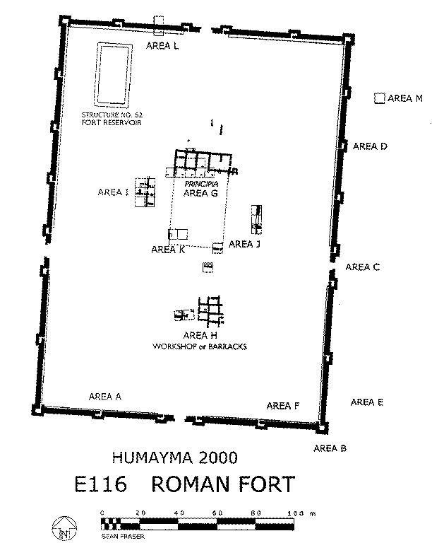
We have already excavated enough of the Roman fort in Field E116 to understand the chronology and plan of the fortification wall and the interior network of parade ground and streets, and to define the character of two major internal structures: the Principia (headquarters building and shrine), and Praetorium (commander's residence). Relatively small areas of the barracks, a workshop, and possible stables or granaries have also been probed. Although evidence for the history and development of this large military complex is still fragmentary, the spectacular results of my excavations have already had a marked effect on the very vigorous field of Roman military history in the Near East. D. Kennedy, the noted expert on Roman military architecture in Jordan, characterizes the fort as "outstanding"that rarity in the Middle East, an early Roman imperial fort" (Kennedy 2000: 182). The circuit walls with their projecting towers are "especially important for the study of military architecture in the East" (Kennedy 2000: 183). Gregory, an expert on Roman forts of the eastern frontier, concludes (1996: 196) that the fort is a "suggestive 'missing link'" and that it "caused a stir among those interested in such matters." The fort at Humayma clearly is critical to our understanding of Roman occupation along the eastern frontier. I would like to test through excavation my working hypotheses concerning the character of the Roman occupation. In summary, it seems that the local Nabataean culture had more influence on the fort and its material culture than the "Romans" in the fort had on the community (Oleson, Forthcoming, "Romanization"; Oleson, Reeves, Fisher, Forthcoming). Excavation of both fort and vicus structures will help evaluate this hypothesis. Geophysical survey will contribute to a complete plan of fort and vicus.
3. Scholarly Context and Background of Project.
Ancient Hawara (in Greek, Auara; in Latin, Hauarra), now officially called Humayma (formerly, Humeima), was a small desert trading post and caravan way-station in Edom, the desert region of southern Jordan (Locator map). According to Ouranios's Arabika (FGrH 675 frag. A.1.b), Hawara was founded by the Nabataean King Aretas III in the 80s B.C. Although this date is not yet archaeologically attested, the settlement did exist by at least the later first century B.C. The location and historical context suggest it was intended to serve as a centre for sedentarization of the nomadic Nabataean pastoralists who occupied the region. Through careful management of the meager spring water and precipitation, the resulting community was able to enjoy a settled existence based on agriculture, stock-raising, and the servicing of caravans. A modest prosperity continued through the Roman, Byzantine, and early Islamic periods, based in part on the trade that continued to move along the N/S Via Nova Traiana, built by Trajan on the old Nabataean route. The Abbasid family purchased the town site late in the seventh century, built a qasr (fortified house) and family mosque (identified in 1993), and plotted the overthrow of the Umayyad caliphate there. After the success of their conspiracy in the mid-eighth century, and the shift of the caliphate to Baghdad, the site was essentially abandoned. The name and historical associations of the site survived among Arab historians and are still familiar to the local Bedouin.
I surveyed the regional water-supply systems in 1986-89 (Oleson 1986-92) and excavated probes along the aqueduct and at a number of cisterns and reservoirs in the settlement centre (Regional survey map). A Roman/Byzantine bath associated with the fort was completely excavated. The continuity of occupation in the settlement centre at Humayma across several critical historical periods, the impressive architectural remains, and the absence of modern occupation or serious disturbance at the site led me to undertake the probing and excavation of other structures in the habitation centre and the preparation of an overall site map in seven field seasons between 1991 and 2000 (Oleson et al. 1993-97, 1999). The field work has been carefully focused on critical structures and areas of the large site in order to elucidate every stage of its history, from first settlement to abandonment. The strategy of using both exploratory probes and focused excavation has succeeded admirably.
Several major clusters of research questions have guided our past excavations.
1) What were the chronology, architectural character, and economic structures of the earliest settlement, and can the example of Hawara cast any light on the process of sedentarization that Nabataean society as a whole was going through in the first century B.C.?
2) What role did the water-supply system play in the location and design of the settlement?
3) When did the Roman occupation of the site begin, and how did Roman administration and influence affect the water-supply system, settlement design, structures, and the local culture? What role did the fort play as part of the eastern imperial frontier?
4) What was the chronology and what was the nature of the Christianization of Hawara, and how deeply did Christianity and Byzantine culture affect the local people?
5) What effect did the arrival of Islam have on the settlement and its inhabitants, and where did the Abbasid family build their historically attested qasr and mosque?
After summarizing the data we have recovered that help to answer each of these research foci, I will relate these accomplishments to our plans for three more seasons of study and excavation focused on question 3.
1) Nabataean Hawara.
In 1991-93 I hoped to find evidence for the earliest, presumably early first century B.C., occupation of the site in the centre of the settlement, near some reservoirs of typical Nabataean design (site plan, nos. 67-68). Because of the presence of deep silt deposits laid down during the Byzantine period and of unexpectedly rich Islamic occupation strata, only traces of early first-century A.C. Nabataean structures and"surprisingly"tombs were recovered there by 1993. Survey and spot excavation in the plundered rock-cut tombs surrounding the town, however, yielded coins and ceramics that provided ample evidence for the Nabataean occupation of Hawara, at some point in the first century B.C.
In 1996 we finally identified and excavated two Nabataean occupation areas. Area C124, an open field adjacent to a Nabataean type cistern on the south edge of the settlement, yielded enormous amounts of first-century A.C. Nabataean pottery and many contemporary coins. The character of the deposits suggests a campground for caravans or seasonal inhabitants of Hawara, located adjacent to a handy source of water. While this campground did not date to the earliest historically attested phase of the site, it corresponds with the usual model for Nabataean urbanism, in which nomadic behaviour helps create settlements and continues alongside permanent architecture (Köhler-Rollefson 1987; Rosen & Avni 1993; Haiman 1995). This model has been documented at Petra (Stucky et al. 1996; Pflüger 1995: 283).
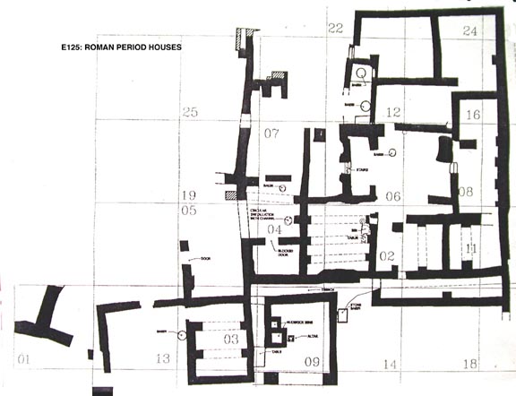
In another open field, south of the Roman fort and above the settlement centre, we uncovered the remains of several Nabataean structures in 1995-96 and 1998-2000 beneath later buildings that belonged to the vicus, the civilian settlement serving the fort. The Nabataean house at E122 was rebuilt on more or less its original plan in the early second century A.C. The other structure, beneath the south end of E125 may have been a shrine or temple. Structure E125 (plan) is a multi-room occupation area (possibly several separate homes) constructed in the late second century of mud brick walls reinforced with beautifully carved stone door sills and jambs, with stone arches to support the roof. Large fragments of painted frescoes were found, including mythological, human, and animal figures, and a rich array of artifacts. A shrine built over the Nabataean structure contained a column representing the Nabataean god Dushara, dedications to Jupiter Ammon and to Serapis, and unique geometric frescoes. The Latin inscription on the altar to Jupiter Ammon indicates that the soldiers stationed at the fort belonged to the Third Legion Cyrenaica, one of the two legions involved in the conquest of the Nabataean kingdom (Oleson, Reeves, Fisher, Forthcoming). Geophysical survey with ground-penetrating radar (GPR), resistivity, and magnetometry methods, proposed for the study season in 2002 with some follow-up in 2003, will allow us to clarify the extent and arrangement of the vicus without time-consuming and expensive excavation. A few probes will be executed in 2003 on the basis of the plan generated by the survey, to answer questions of chronology and design.
2) Nature of the Water-Supply System.
The water-supply system of Hawara was regional in scale and integrated with the settlement design, and the settlement location seems to have been selected with this critical consideration in mind (Oleson 1992b, 1997a). The settlement is located at the conflux of several run-off fields that provide a reliable supply and manageable amount of water to two public reservoirs and numerous private, domestic cisterns. Furthermore, it sits at the southernmost point that could conveniently be reached by a gravity flow aqueduct fed by springs on the escarpment 15 km to the north, and it is near good agricultural soil and a route to the Wadi Arabah. The scale of the first-century B.C. or A.C. public reservoirs and aqueduct indicate central, probably royal, planning and sponsorship. Drainage was more casual, but it also involved some site planning and construction (Oleson 1996). The final report on the water system will be submitted for publication in Dec. 2001 (Oleson, Forthcoming, "Water-Supply").
3) Roman Havarra.
Excavation of portions of the walls and interior structures of the large (148 x 207 m) Roman fort (E116) in 1993, 1995-96, and 2000 revealed that the structure was very well preserved and that it was built several centuries earlier than expected (plan of fort). It was traditionally assumed that the fort was part of Diocletian's reworking of the frontier in the late third century, but we recovered ceramics and coins proving that the structure was built very soon after Trajan's annexation of the Nabataean kingdom in 106. This is the earliest large Roman fort known in Jordan (see Parker 1986, 1992, Kennedy 2001: 182-83), and the use of a rectangular plan with projecting towers at such an early date has derailed theories concerning the development of Roman forts in the East (Gregory 1995, 1996). We have documented a decline in activity at the fort in the later third century, rebuilding of some interior structures in the fourth"possibly for non-military occupation"and abandonment early in the fifth century (Oleson et al. 1995-97, 1999). Our knowledge of the interior structures is outlined above in "Objectives," and below in "Proposed."
4) Christianity at Havarra.
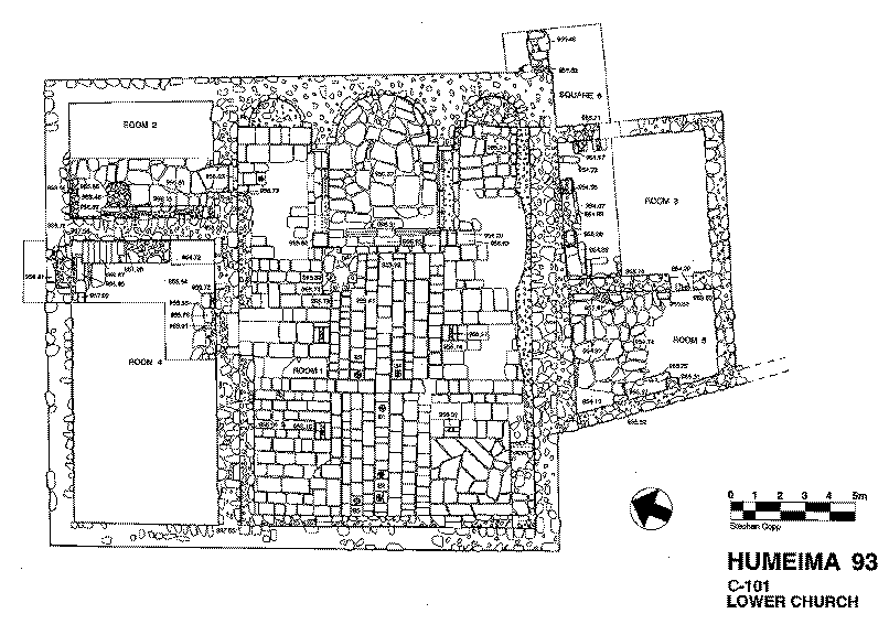
There were probably Christians resident at Hawara from at least the third century A.C. onward, given the early and enthusiastic interest of Arab groups in the new religion, particularly in the Provincia Arabia (Shahîd 1984: 36-37, 65-94, 154-56). The first physical evidence, however, are the churches, which begin to appear around A.D. 400 (Schick 1995a-b, 2001). We have excavated and consolidated the largest and best preserved of these (plan of C101), a three apse basilica with chancel, fine marble chancel screen, five undisturbed burials, sacristy and side entrance hall. A small, single-apse chapel (C119)"but with painted plaster walls, marble fittings, and glass lamps"was partly excavated on the western slope overlooking the site in 1993. Subsequently, we recognized that two sprawling early Islamic habitations under excavation (B100 and F102) had been built into and on top of two more, large, single apse churches, and that a late Ottoman house near the centre of the site concealed the remains of yet another large, single-apse church (B126)(for preliminary reports, see Oleson et al. 1993, 1995, 1999).
The inhabitants of Hawara built at least five substantial churches, the same number as at the larger mining centre of Feinan, and one more than the number so far identified at the regional capital of Petra. This total seems to be excessive for a settlement with a population of no more than 650 persons, many of them probably resident at the site only part of the year and living in tents (Oleson 1997: 181-82). It is possible that the doctrinal disputes endemic to this era fostered separate congregations, or that some of the churches were derelict when others were built. Although Hawara must have been thoroughly christianized by A.D. 400, the fort has not yet yielded any evidence for Christian practices, raising interesting questions about the character of Romanization at the site and the intensity of interaction between the soldiers and the civilians.
5) Early Islamic Humayma and the Abbasid Family.
Christianity withered away quickly after the arrival of Islam in the mid-seventh century. At least two of the churches (C101 and B100) were abandoned for a time, then destroyed by fire. Three of them (B100, B126, and F102) were divided up by party walls and reoccupied as habitations in the early Islamic period, prior to final abandonment in the first half of the eighth century. The initial occupation of the region by Islamic forces was largely peaceful, but by the late seventh century the Christian population of Hawara"now called Humayma"had converted or departed (Schick 1995a-b; Fiema 1992). According to early Arabic historians, around 687/8, "Ali ibn "Abd Allah ibn al-"Abbas purchased the town and built a qasr (fortified house) and mosque. Here, the Abbasids plotted their revolt against the Umayyad dynasty, which was carried out in 749 (Oleson et al. 1996c; Schick, Forthcoming). The family then left for Persia, and the site of Humayma was abandoned.
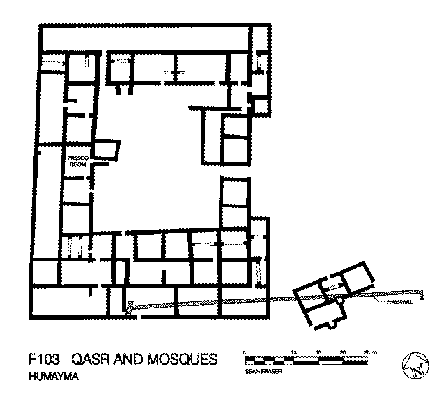
We identified the Abbasid qasr in 1993. It is a rectangular structure (ca. 61 x 50 m) consisting of a large trapezoidal courtyard surrounded by rooms fronting the court (plan of qasr) There was a wide, recessed entrance on the east, and a small mosque (ca. 5.7 m sq.) outside the southwest corner. Ceramics and coins provide rich and precise documentation of the date, and the remains of frescoes and carved ivory furniture indicate a taste for luxury and wide commercial connections appropriate to this politically active family (Foote 1999; Oleson et al. 1999: 436-43).
4. Proposed Geophysical Survey and Excavation of the Fort and Vicus, 2002-4.
The fort was built above the settlement centre, but adjacent to the Nabataean "neighborhood" noted above, and the Nabataean aqueduct and reservoir. A branch line from the aqueduct fed a secure reservoir inside the fort. The fort had a clear view of the route of the Via Nova for 15 km to the north and south. Trajan built this road on the lines of the earlier Nabataean trade route, to facilitate communication through his new province, from the capital of Bostra on the north to Aila (Aqaba) on the Red Sea (Graf 1995). In 1996 a silver coin struck by Trajan at Bostra was found in the fort. Clearly, early on in the history of the Provincia Arabia, Hawara (now also called Auara and Hauarra) was seen to have an important potential role to play in its administration (cf. Freeman 1996). The isolation of the settlement and fort indicate that the garrison was meant to administer the region and ensure peace along the road, rather than to guard against any threat external to the empire. Graf (1997c) provides a summary of the long dispute about the character of frontier forts like that at Hawara. The critical location, early date, and excellent preservation of this fort make it uniquely important for the original scope of the so-called Arabian Limes (protected frontier), and Trajan's eastern policy in general. The apparent decline or abandonment of the fort during the reign of Diocletian may indicate that he withdrew the garrison during his reworking of the eastern frontier, because his concept of the military role was defensive, not administrative, and Hawara was pacified.
Although we have some knowledge of internal arrangements in the fort, I need to verify the plan of the praetorium and the design and extent of its mosaics (see fort plan, Area I), and the plan and function of the stables and/or granary structure found in 2000 (see fort plan, Area J). The mosaics, unique in the Hisma, are important evidence for collaboration between the Roman administrators and Nabataean workmen immediately after the conquest, since the motifs used find precise parallels in mosaics in late first-century Nabataean houses at Wadi Musa (Oleson et al, 2001). In addition, their designs, in combination with the programme of the wall frescoes, will help determine the function of the various rooms in the building. We may already have isolated a formal dining chamber. The scholarly literature has always interpreted the term equites in the context of Roman military forces in the desert to mean horse-mounted cavalry, but I believe that at sites like Hawara maintenance of horses would be impossible without the importation of fodder. I prefer to interpret the equites sagittarii indigenae (mounted archers of local origin) mentioned at Hawara by the fifth-century Notitia Dignitatum (Or. XXXIV.25; Shahîd 1984: 51, 61) as camel riders (cf. Dabrowa 1991, Dixon and Southern 1992). Identification and examination of stables in the fort should clarify the type of animals kept by the unit, and thus supply hints about the strategy and tactics of regional control. I would like as well to determine the source, destination, and function of the pressurized water pipeline discovered in 2000 outside the SE corner of the central parade ground. The pipeline must originate at the large reservoir in the NW quadrant of the fort, and it is possible that a water-lifting device was installed there to service the pipeline. Such a device (relevant to another of my research areas), would, like the large Roman bronze stopcock I found installed in the Nabataean Reservoir in 1987 (Oleson 1988: pl. 30), be unique at this period in the Near East. It is possible that this early fort had a particularly Italian/Roman character, marked by the appearance of technologies more common in the western provinces. The pipeline may have served a latrine in the SE (downhill) quadrant of the fort, another unique feature in the forts of the region at this time.
In order to facilitate preparation of a plan of the remaining structures in the fort, as well as the extent and arrangement of the vicus to the south, we plan a campaign of geophysical survey with ground-penetrating radar (GPR), magnetometry, and resistivity equipment in 2002 and 2003. These techniques can provide a surprisingly clear indication of the plans of buried structures and will allow refinement of the programme of excavation for 2003-4. GPR was used last summer on a similar soil type at Petra by a noted expert "with the best results [he has] ever seen" (Conyers, oral communication 9/09/01). An experiment by a Jordanian geology team at Humayma (Zoubi, Haddadin, Batayneh 1998) has shown that magnetometry and resistivity equipment will work well at Humayma, too. By combining information from the geophysical surveys, existing aerial photographs, probes, and excavation, I hope to be able to construct a virtually complete plan of the fort by the end of the 2004 season. The creation of this plan and definition of the individual structures, along with the accumulation of excavated artifacts, should answer many of our remaining questions concerning the size and character of the unit or units stationed in the fort during the period it functioned, and their interaction with the community. These interactions can be documented through shared or exclusive ceramic types, patterns of faunal remains, tool types, art forms (such as mosaic and fresco), and inscriptions. Although Nabataean ceramic wares were in common use in the fort during the second century, many of the third and fourth-century cooking wares were nearly exclusive to the fort. A possible kiln site containing wasters of just these types of cooking wares was noted 500 m west of the fort in 2000. The magnetometry survey will be particularly important for this feature. I plan to excavate the kiln in 2003 in order to determine its relevance to the ceramics used in the fort. Verification of the production of a distinctive military cooking kit at a site lacking potter's clay and possessing little water or fuel will force re-evaluation of conceptions concerning the provisioning of these early frontier forts.
Roman forts, occupied by hundreds of soldiers, did not exist in isolation. They were either located at the edge of an existing community or a new community sprang up outside their walls to service the garrison within. Soldiers went to these vici for recreation (baths, taverns, and brothels), for worship, to visit their unofficial families, or to purchase staples or luxuries not available in the fort itself (Le Bohec 1994: 226). From these examples, it is clear that in order to fully understand Hawara's garrison, we need to understand the community which interacted with it. Moreover, this community, which our evidence to date suggests was composed of Nabataean and Romanized Egyptians, has the potential to tell us a great deal about interactions between the Romans and the indigenous people in the decades following the annexation of the Nabataean kingdom, a period that is still poorly understood.
Excavation has revealed several Roman-period buildings belonging to the vicus located SW of the fort: the garrison's bath-house (E077) and two domestic complexes (E122 and E125). Although excavation of these buildings has given us numerous details of vicus life, we still do not know the size, extent or composition of the vicus as a whole. Although vicus structures might be located anywhere outside the fort, the typical mud brick construction makes it difficult to detect these structures even with aerial photographs. The topography and soil conditions, however, are well-suited to the use of ground-penetrating radar (GPR). Vicus structures are frequently concentrated on one side of a fort, and an analysis of the vici in Britain suggests that an extra-mural military bath-house attracted such communities (Sommer 1984). The pattern at Hawara seems similar, but we will test this hypothesis by placing several GPR survey grids outside the N and E gates of the fort. The rest of the grids will be positioned around the known structures SW of the fort in an attempt to determine the extent and organization of the settlement, and possibly allowing identification of the various types of buildings within the vicus such as temples, houses, shops, brothels. We will probe a representative sample of the structures to determine their function and chronology, and whether they were built on top of earlier Nabataean structures. So far, evidence is consistent that major Nabataean buildings at Hawara were derelict in the Roman period, and blocks from these structures were used as building materials in the Roman fort. New probes in the vicus may clarify whether Hawara was destroyed at the time of the Roman conquest, as now seems to be the case at Petra (Schmidt 1997), or by an earlier natural calamity.
5. The Excavation and Research Team.
The excavation and interpretation of the remains of an ancient settlement centre such as Humayma requires expertise in a wide variety of fields. I remains the Project Director, with final say on the intellectual and practical direction of the project. Since beginning excavation of the habitation centre in 1991, however, I have worked with several co-directors, each of whom made his or her own special contribution: Dr. Khairieh "Amr (1991-96), an archaeologist with the Jordanian Department of Antiquities (ceramics and Early Islamic archaeology), Dr. Robert Schick (1991-97) Byzantine period architecture), and Dr. Rebecca Foote of the Islamic Art Institute in London (1993-present; early Islamic commercial and domestic structures). Together, we reinforce each other's professional competence, and we are all contributors to the interim and final publications. In 1998 and 2000, I asked two of my former students working with me at Humayma, M. Barbara Reeves (PhD candidate, SUNY Buffalo) and Erik de Bruijn (PhD candidate, University of British Columbia) to serve as Assistant Directors and share some of the responsibilities for field direction, communication, and publication. They will continue to function in this capacity during the next three years. In 2002 Dr. Andrew Sherwood of Guelph University, who participated in the surveys in 1986-87, will rejoin the project as Assistant Director. Dr. Gregory Baker of SUNY-Buffalo will also join the project in 2002-3, to direct the geophysical survey of the Roman fort and vicus.
Our ceramics expert is Yvonne Gerber (University of Basel), who has taken over that role from Dr. "Amr. Our conservator since 1993 has been Judy Logan (Canadian Conservation Institute). Sean Fraser is the project architect. I am the project photographer. Other individuals contribute to the project but do not take part in the field work: M. Finnegan (Kansas State University), mammal bones; D. Reese (Peabody Museum, Yale Univ.), mollusks; J. Studer (Muséum d"histoire naturelle, Geneva), fish bones; P. Warnock (Univ. of Missouri), botanical remains; Dr. J. Jones (Bucknell Univ.), glass; B. Seymour (Royal B.C. Museum), non-ceramic draughtsman.
6. Bibliography Relevant to the Project
2000 Rome in the East. The Transformation of an Empire. London: Routledge.
1998 "Environment and Land Use in the Wadi Faynan, Southern Jordan: the Second Season of Geoarchaeology and Landscape Archaeology (1997)." Levant 30: 5-25.
-----, and R. Adams, O. H. Creighton, D. Crook, D. D. Gilbertson, J. P. Grattan, C. O. Hunt, D. J. Mattingly, S. J. McLaren, H. A. Mohammed, P. Newson, C. Palmer, F. B. Pyatt, T. E. G. Reynolds, R. Tomber.
1999 "Environment and Land Use in the Wadi Faynan, Southern Jordan: the Third Season of Geoarchaeology and Landscape Archaeology (1998)." Levant 31: 255-92.
-----, and D. Gilbertson, B. Jones, D. Mattingly.
1996 Farming the Desert. Vol. 1: Synthesis. Vol. 2: Gazetteer and Pottery. London: Society for Libyan Studies.
Banning, Edward B.
1986 "Peasants, Pastoralists and Pax Romana: Mutualism in the Southern Highlands of Jordan." Bulletin of the American Schools of Oriental Research 261: 25-50.
1987 "De Bello Paceque: A Reply to Parker." Bulletin of the American Schools of Oriental Research 265: 52-54.
Bidwell, Paul; Miket, Roger; Ford, Bill. Eds.
1988 Portae cum turribus: Studies of Roman fort gates. BAR British Series, 206. Oxford: BAR.
Blagg, T.F.C.
2000 "The Architecture of the Legionary Principia." Pp. 139-47 in R.J. Brewer, ed., Roman Fortresses and their Legions. London: Society of Antiquaries.
Bowersock, Glen W.
1983 Roman Arabia. Cambridge, MA: Harvard University Press.
1984 "Nabataeans and Romans in the Wadi Sirhan." Pp. 133-36 in A.M. Abdalla, ed., Studies in the Historia of Arabia, II. Riyadh: King Saud University Press.
1997 "Polythesism and Monotheism in Arabia and the Three Palestines." Dumbarton Oaks papers 51: 1-10.
Connolly, Peter, and David Davison, Carol Van Driel-Murray
1989 The barracks of the Roman army from the 1st to 3rd centuries A.D.: a comparative study of the barracks from fortresses, forts and fortlets with an analysis of building types and construction, stabling and garrisons. British Archaeological Reports Intl. Ser., 472. Oxford: BAR.
Dabrowa, Edward.
1991 "Dromedarii in the Roman Army: A Note." Pp. 364-66 in V.A. Maxfield, M.J. Dobson, Roman Frontier Studies, 1989. Proceedings of the XVth International Congress of Roman Frontier Studies. Exeter: University of Exeter Press.
deVries, Bert
1986 "Umm el-Jimal in the First Three Centuries A.D." Pp. 227-241 in P. Freeman and D. Kennedy, ed., The Defence of the Roman and Byzantine East. Oxford: BAR.
1998 Umm el-Jimal: A Frontier Town and its Landscape in Northern Jordan, vol. I. Journal of Roman Archaeology, Suppl. 26. Portsmouth: JRA.
Dixon, Karen, and P. Southern
1992 Roman Cavalry. London: Routledge.
1996 The Late Roman Army. London: Batsford.
Eadie, J.
1986 "The Evolution of the Roman Frontier in Arabia." Pp. 243-52 in P. Freedman, and D. Kennedy, eds., The Defence of the Roman and Byzantine East. British Archaeological Reports, Intl. Ser., 297. Oxford: B.A.R.
-----, and Oleson, J.P.
1986 "The Water-Supply Systems of Nabataean and Roman Humayma." Bulletin of the American Schools of Oriental Research 262: 49-76.
Evans, Edith
1994 "Military Architects and Building Design in Roman Britain." Britannia 25: 143-64.
Fiema, Zbigniew
1991 Economics, Administration, and Demography of Late Roman and Byzantine Southern Transjordan. Ph.D. diss., University of Utah.
1992 "The Islamic Conquest of Southern Jordan: A New Research Perspective." Annual of the Department of Antiquities of Jordan 36: 325-31.
1999 "Frescoes and carved ivory from the Abbasid family homestead at Humeima." Journal of Roman Archaeology 12: 423-28.
1996 "Humeima Excavation Project, 1995-96." Fondation Max van Berchem Bulletin 10 (December 1996) 1-4.
2000 "Les ivoires d'un palais abbasside." Le monde de la Bible 124: 67.
1996 "The Annexation of Arabia and Imperial Grand Strategy." Pp. 91-118 in D.L. Kennedy, ed., The Roman Army in the East. Journal of Roman Archaeology, Supp. 18. Ann Arbor: JRA.
1990 "Arabia during Achaemenid Times." Pp. 131-48 in H. Sancisi-Weerdenburg, A. Kuhrt, eds., Achaemenid History, IV. Leiden: Instituit voor het Nabije Oosten.
1992 "Nabataean Settlements and Roman Occupation in Arabia Petraea." Pp. 253-60 in G. Bisheh, ed., Studies in the History and Archaeology of Jordan, IV. Amman: Department of Antiquities.
1995 "The Via Nova Traiana in Arabia Petraea." Pp. 241-67 in J.H. Humphrey, ed., The Roman and Byzantine Near East: Some Recent Archaeological Research. JRA Suppl. 14. Ann Arbor: Journal of Roman Archaeology.
1997a "The Via Militaris and the Limes Arabicus." Pp. 123-33 in W. Goernman et al. eds., Roman Frontier Studies 1995: Proceedings of the XVIth International Congress of Roman Frontier Studies. Oxbow Monograph 91. Oxford: Oxbow.
1997b Rome and the Arabian Frontier from Nabateans to Saracens. Brookfield: Variorum.
1997c "The Via Militaris in Arabia." Dumbarton Oaks Papers 51: 271-81.
2000 "Town and Countryside in Roman Arabia during Late Antiquity." Pp. 219-40 in T. Burns, J. Eadie, eds. Urban Centers and Rural Contexts in Late Antiquity. East Lansing: Michigan State University Press.
2001 "First Millennium AD: Roman and Byantine Periods Landscape Archaeology and Settlement Patterns." Pp. 469-80 in Studies in the History and Archaeology of Jordan, VII. Amman: Department of Antiquities.
1994 Roman Military Architecture on the Eastern Frontier, A.D. 200-600. Amsterdam: Hakkert.
1996 "Was There an Eastern Origin for the Design of Late Roman Fortifications." Pp. 169-210 in D.L. Kennedy, ed.,The Roman Army in the East. Journal of Roman Archaeology, Supp. 18. Ann Arbor: JRA.
1995 "Agriculture and Nomad-State Relations in the Negev Desert in the Byzantine and Early Islamic Periods." Bulletin of the American Schools of Oriental Research 297: 29-53.
1986 "Some Preliminary Thoughts on Settlement in Southern Jordan." Levant 18: 51-58.
1990 The Limits of Empire: The Roman Army in the East. Oxford: Oxford University Press.
1983 Roman Forts of the 1st and 2nd Centuries AD in Britain and the German Provinces. London: Adam & Charles Black.
1987 "Ethnoarchaeological Research into the Origins of Pastoralism." Annual of the Department of Antiquities of Jordan 31: 535-42.
1996 "The Roman Army in the East." Pp. 9-24 in D. L. Kennedy, ed., The Roman Army in the East. JRA Supp., 18. Ann Arbor: JRA.
1999 "Greek, Roman, and native cultures in the Roman Near East." Pp. 77-106 in J.H. Humphrey ed., The Roman and Byzantine Near East, vol. 2: Some Recent Archaeological Research. JRA Supp. 31. Portsmouth RI: Journal of Roman Archaeology.
1991 Hesban I: Sedentarization and Nomadization. Berrien Springs: Andrews University.
1994 Imperial Roman Army. London: Batsford.
1999 "Redating the forts at Ein Boqeq, Upper Zohar, and other sites in SE Judaea, and the implications for the nature of the Limes Palaestinae." Pp. 189-206 in J.H. Humphrey ed., The Roman and Byzantine Near East, vol. 2: Some Recent Archaeological Research. JRA Supp. 31. Portsmouth RI: Journal of Roman Archaeology.
1976 "The Early Beginnings of the Nabataean Realm." Palestine Exploration Quarterly 108: 125-33.
1977 "The Nabateans and the Provincia Arabia." ANRW II.8: 520-686.
1986 Nabatean Archaeology Today. New York: New York University.
1988 The Architecture of Mampsis, II: The Late Roman and Byzantine Periods. Qedem, 27. Jerusalem: Hebrew University.
1986 "The Humayma Hydraulic Survey: Preliminary Report of the 1986 Season." Annual of the Department of Antiquities of Jordan 30: 253-60, pls. 43-47.
1987a "The Humayma Hydraulic Survey: Preliminary Report of the 1986 Season." Classical Views/Echos du Monde Classique 31: 263-72.
1987b "Technology and Society in Ancient Edom." Transactions of the Royal Society of Canada Ser. 5, vol. 2: 163-74.
1988a "Nabataean and Roman Water Use in Edom: The Humayma Hydraulic Survey, 1987." Echos du Monde Classique/Classical Views 32: 117-29.
1988b "The Humayma Hydraulic Survey: Preliminary Report of the 1987 Season," Annual of the Department of Antiquities of Jordan 32: 157-69, pls. 26-32.
1990a "Humeima Hydraulic Survey, 1989: Preliminary Field Report." Echos du Monde Classique/Classical Views 9: 145-63.
1990b "The Humeima Hydraulic Survey: Preliminary Report of the 1989 Season," Annual of the Department of Antiquities of Jordan 34: 285-312.
1992a "Aqueducts, Cisterns, and the Strategy of Water Supply at Nabataean and Roman Auara (Jordan)." Pp. 45-62 in E.T. Hodge (ed.), Future Currents in Aqueduct Studies. Bristol: Francis Cairns Press.
1992b "The Water-Supply System of Ancient Auara." Pp. 269-76 in G. Bisheh, ed., Studies in the History and Archaeology of Jordan, IV. Amman: Department of Antiquities.
1992c "Hellenistic and Roman Elements in Nabataean Hydraulic Technology." Pp. 473-97 in G. Argoud et al. eds., L'Eau et les Hommes en Méditerranée et en Mer Noire dans L'Antiquité. Athens: Centre de Recherches Néo-Helléniques.
1992d "Water Works." Pp. 883-93 in D.N. Freedman, etc., Anchor Bible Dictionary, vol. VI. New York: Doubleday.
1994 "Un poste-clé: el-Humeima." Le monde de la Bible 88: 38-39.
1995 "The Origins and Design of Nabataean Water-Supply Systems." Pp. 707-19 in K. 'Amr, M. Zaghloul, eds., Studies in the History and Archaeology of Jordan, V. Amman: Department of Antiquities.
1996 "Surface Water Management at an Ancient Site in Jordan's Southern Desert," Acts, 16th Congress of the International Commission on Irrigation and Drainage, Cairo, 1966. Cairo, pp. 141-56.
1997a "Landscape and Cityscape in the Hisma: The Resources of Ancient Al-Humayma." Pp. 175-88 in Studies in the History and Archaeology of Jordan, VI. Amman: Department of Antiquities.
1997b "Humeima." In E. Meyers, ed., Oxford Encyclopedia of Archaeology in the Near East, vol. 3, pp. 121-22. Oxford: Oxford University Press.
1997c "Al-Humayma Excavation Project, 1996," Ancient Jordan: Newsletter of the Jordanian Friends of Archaeology Society. July/August: 6-7.
2001a "Water-Supply in Jordan," pp. 603-14 in B. MacDonald et al. eds., The Archaeology of Jordan. Sheffield: Sheffield Academic Press.
2001b "King, Emperor, Priest, and Caliph: Cultural Change at Hawara (Ancient al-Humayma) in the First Millennium AD." Pp. 569-580 in Studies in the History and Archaeology of Jordan, VII. Amman: Department of Antiquities.
Forthcoming Humayma Excavation Project, Final Report, vol. I: The Site and the Water-Supply System. To be published as a Supplements to the Journal of Roman Archaeology.
1993a "Humeima Hydraulic Survey, 1989." Syria 70: 248-54.
1993b "The Humeima Excavation Project, Jordan: Preliminary Report of the 1992 Season," Echos du monde classique/Classical Views 12: 123-58.
1993c "The Humeima Excavation Project, Jordan: Preliminary Report of the 1991-1992 Seasons," Annual of the Department of Antiquities of Jordan 37: 461-502.
1993d "Humeima." Pp. 513-14 in B. de Vries, P. Bikai, "Archaeology in Jordan," American Journal of Archaeology 97: 457-520.
1994a "The Humeima Excavation Project, Jordan: Preliminary Report of the 1993 Season," Echos du monde classique/Classical Views 13: 141-79.
1994b "Humeima," pp. 548-49 in G. Peterman, "Archaeology in Jordan,"American Journal of Archaeology 98: 521-59.
1995 "Preliminary Report of the Humeima Excavation Project, 1993," Annual of the Department of Antiquities of Jordan 39: 317-54.
1996a "Characterization of Pigments Used on Roman and Abbasid Frescoes in Jordan," ICOM Committee for Conservation, 11th Triennial Meeting, Edinburgh, Scotland, Preprints. London: James & James, pp. 423-29.
1996b "Humeima." Pp. 528-30 in P. Bikai, V. Egan, eds., "Archaeology in Jordan," American Journal of Archaeology 100: 507-35.
1996c "Humeima Excavation Project, 1995-96," Fondation Max van Berchem Bulletin 10 (December): 1-4.
1996d "Humeima," in ACOR Newsletter 8.1: 8-9 (co-author).
1997 "Humeima." Pp. 518-20 in P. Bikai, V. Egan, eds., "Archaeology in Jordan," American Journal of Archaeology 101: 493-535.
1999a "Preliminary Report of the al-Humayma Excavation Project, 1995, 1996, 1998," Annual of the Department of Antiquities of Jordan 43: 411-50.
1999b "Humeima." Pp. 513-14 in P. Bikai, V. Egan, eds., "Archaeology in Jordan," American Journal of Archaeology 103: 485-520.
2001 "Humayma." Pp. 456-57 in S. Savage, et al., eds., "Archaeology in Jordan," American Journal of Archaeology 105: 427-61.
1989 "Humayma." Pp. 270-74 in D. Homès-Fredericq, J.B. Hennessy, eds., Archaeology of Jordan, II: Field Reports. Akkadica, Supp. VII. Leuven: Peeters.
Forthcoming New Dedicatory Inscriptions from Humayma (Ancient Hawara), Jordan." Submitted to Zeitschrift für Papyrologie und Epigraphik.
1986 The Historical Development of the Limes Arabicus. Cambridge, MA: American Schools of Oriental Research.
1987a "Peasants, Pastoralists, and Pax Romana: A Different View." Bulletin of the American Schools of Oriental Research 265: 35-51.
1987b The Roman Frontier in Central Jordan: Interim Report on the Limes Arabicus Project, 1980-85. British Archaeological Reports, Intl. Series, 340. Oxford: B.A.R.
1989 "The Fourth Century Garrison of Arabia: Strategic Implications for the South-Eastern Frontier." Pp. 355-72 in D. H. French & C. S. Lightfoot, eds. The Eastern Frontier of the Roman Empire. British Archaeological Reports, no. 553. Oxford: B.A.R.
1992 "The Limes and Settlement Patterns in Central Jordan." Pp. 321-26 in G. Bisheh, ed., Studies in the History and Archaeology of Jordan, IV. Amman: Department of Antiquities.
1996 "The Roman Aqaba Project: The 1994 Campaign." Annual of the Department of Antiquities of Jordan 40: 231-257.
1997 "Geography and Strategy on the Southeastern Frontier in the Late Roman Period." Pp. 115-22 in W. Groenman-van Waaterringe et al., eds. Roman Frontier Studies 1995. Proceedings of the XVIth International Congress of Roman Frontier Studies. Oxford: Oxbow.
2000a "Roman Legionary Fortresses in the East." Pp. 121-38 in R.J. Brewer, ed., Roman Fortresses and their Legions: Papers in honour of George C. Boon, London: Society of Antiquaries.
2000b "The Defense of Palestine and Transjordan from Diocletian to Heraclius." Pp. 367-88 in L. Stager et al. eds., The Archaeology of Jordan and Beyond: Essays in Honor of James A. Sauer. Winona Lake: Eisenbrauns.
1975 Die Innenbauten römischer Legionslager wahrend der Prinzipatzeit. Opladen: Westdeutscher.
1995 "Archeo-Geology in Petra, Jordan." Annual of the Department of Antiquities in Jordan 39: 281-95.
1996 "The Roman army as "Total Institution" in the Near East? Dura Europos as a Case Study." Pp. 211-27 in D.L. Kennedy, ed., The Roman Army in the East. Journal of Roman Archaeology, Supp. 18. Ann Arbor: JRA.
2000 Soldiers, Cities, and Civilians in Roman Syria. Ann Arbor: University of Michigan Press.
1998 "Two Byzantine Forts in Palaestina Tertia: A Review Article." Levant 30: 203-8.
1989 "Notes sur le Camp Romain de Gholaia (Bu Njem)." Libyan Studies 20: 155-67.
1996 "The Roman Bath-house at Humeima in its Architectural and Social Context." M.A. Thesis, University of Victoria.
-----, and Oleson, John P.
1997 "Baths of the Hisma Desert," Balnearia 5.1: 2-4.
2000 "The Numerical Basis of Roman Camps." Oxford Journal of Archaeology 19: 425-37.
2000 "The decline of desert agriculture: a view from the classical period Negev." Pp. 45-62 in G. Barker, D. Gilbertson, eds., Archaeology of Drylands: Living at the Margin. London: Routledge.
1993 "The Edge of the Empire: The Archaeology of Pastoral Nomads in the Southern Negev Highlands in Late Antiquity." Biblical Archaeologist 56: 189-99.
1996 "Urbanization, Settlement and Agriculture in the Negev Desert"The Impact of the Roman-Byzantine Empire on the Frontier." Zeitschrift des deutschen Palästina-Vereins 112: 49-60.
1992 "Jordan on the Eve of the Muslim Conquest, A.D. 602-634." Pp. 107-119 in P. Canivet, J.-P. Rey-Coquais, eds., La Syrie de Byzance a L'Islam VIIe-VIIIe Siècles. Damascus: Institute Français de Damas.
1995 "Christianity at Humayma, Jordan." Liber Annuus 45: 319-42.
1996 The Christian Communities of Palestine from Byzantine to Islamic Rule. Princeton: Darwin.
2001 "Christianity in Southern Jordan in the Byzantine and Early Islamic Periods." Pp. 581-84 in Studies in the History and Archaeology of Jordan, VII. Amman: Department of Antiquities.
Forthcoming "Humeima and the Abbasid Revolution." Journal of Middle East Studies.
1997 "Nabataean fine ware pottery and the destruction of Petra in the late first and early second century AD." Pp. 413-20 in Ghazi Bisheh et al. (eds.) Studies in the History and Archaeology of Jordan, VI. Amman: Department of Antiquities.
2001 "The "Hellenisation" of the Nabataeans: A New Approach." Pp. 407-19 in Studies in the History and Archaeology of Jordan, VII. Amman: Department of Antiquities.
1983 The Byzantine City of Shivta (Esbeita), Negev Desert, Israel. British Archaeological Reports, Intl. series, 179. Oxford: B.A.R.
1984 Rome and the Arabs. Washington D.C.: Dumbarton Oaks.
1999 "The Roman army in SW Germany as an instrument of colonisation: the relationship of forts to military and civilian vici." Pp. 82-93 in A. Goldsworthy, I. Haynes, eds., The Roman Army as a Community. JRA Supp. 34. Portsmouth RI: JRA.
1996 Petra: az-Zantur, I. Mainz: von Zabern.
1987 Explorations in Doughty's Arabia Deserta. Athens GA: University of Georgia Press.
1998 "Qasr al-Uwainid and Da"ajaniya: Two Roman Military Sites in Jordan." Levant 30: 195-98
1987 Die Nabatäer"Denkmäler und Geschichte. Göttingen: Vanderhoeck & Ruprecht.
1998 "Geophysical Methods for Locating a Prehistoric Site in the Al Hummaymeh Area, Southwest Jordan."Journal of Environmental and Engineering Geophysics 3.3: 157-61.