Land
Taxation
As Kain and Baigent state the
collecting of taxes and state revenues from land and resources drawn
from that
land, has been the overwhelming reason for the cadastral mapping of
land in
Europe (Kain and Baigent 336). In this sense the modern
European
states deployed cadastral systems for the
same reasons as the Roman Empire did, to organize the collection of
state
revenue (Kain and Baigent 336). In the Seventeenth century
Sweden
and the Netherlands used cadastral maps for
this specific purpose (Kain and Baigent 336). After the
Thirty
Years War, economic hardship pushed more governments to employ
cadastral surveys as methods to increase the efficiency of drawing
revenue from
their territory (Kain and Baigent 338).
Back to Top
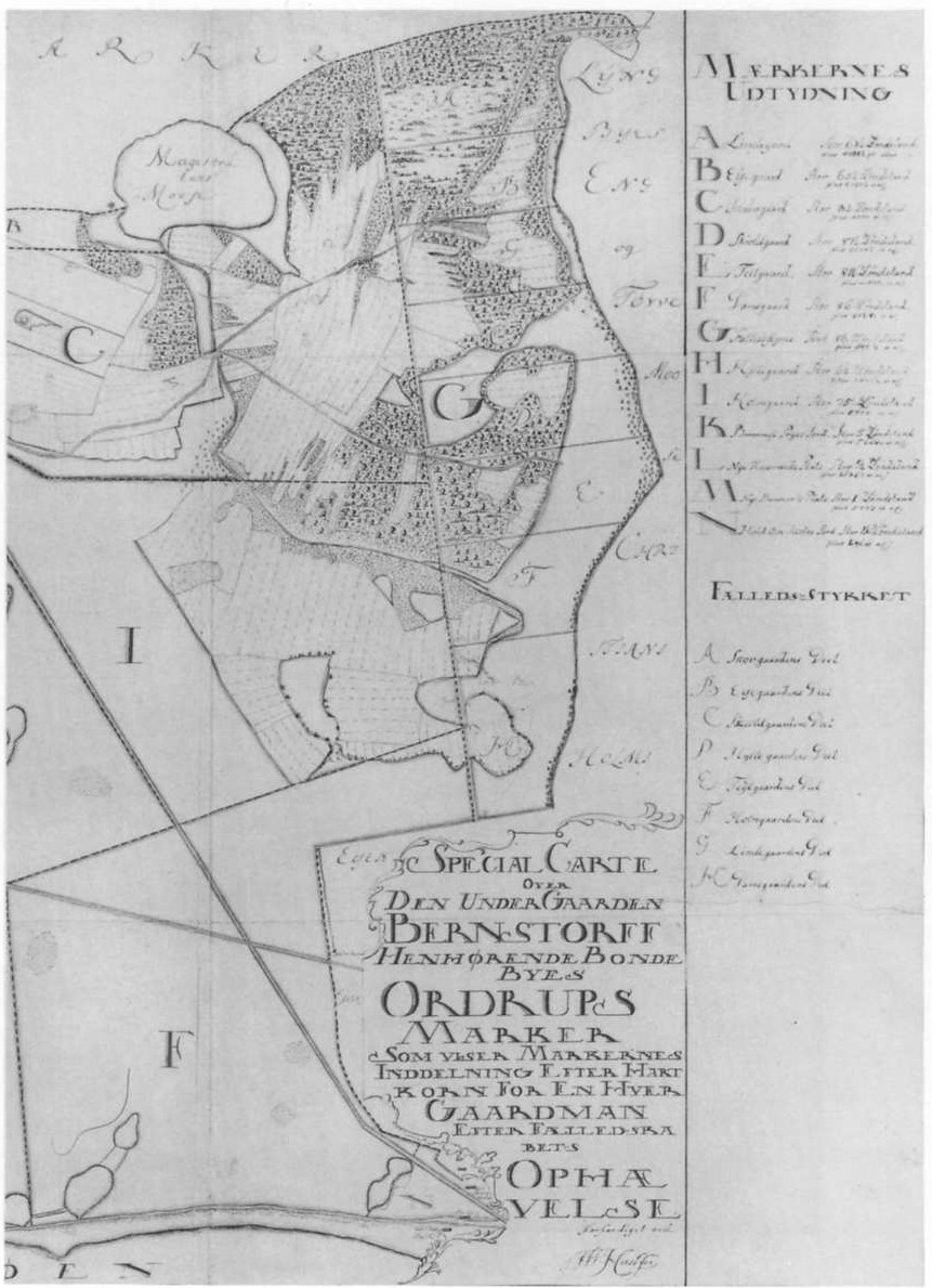
Land Reclamation
In the sixteenth and
seventeenth
centuries in the Netherlands cadastral maps were used to layout land
allotments
formed after the draining of coastal marshes and to
“display” these lots as a
way to attract shareholders and investors who wished to purchase land
(Kain and Baigent 332). Towards similar ends maps were
utilized
in the draining of the Eastern English
Fenland, coastal areas of northern Germany, and in the Veneto valleys
under the
control of the Venetian government (Kain and Baigent 332).
Back to Top
Evaluation
and
Management of State Land Resources
Cadastral maps, because they aim at
creating an exhaustive and accurate account of an areas land holdings,
have
been used as way of creating an inventory of a state’s
resources. One such
example of this is the use of cadastral mapping in Europe to better
assess and
manage timber exploitation. From the seventeenth century on the use of
cadastral mapping techniques for this purpose had been employed in
England,
France, Russia, Germany, and Norway (Kain and Baigent 333).
Back to Top
Land
Redistribution
and Enclosure
The enclosure movement in England
was a prime example of how professional surveyors and cadastral mapping
were
used in the service of the state. As Kain and Baigent argue the goal
for
greater agricultural production, based upon
“rational” and “uniform”
methods of
organization were the underlying reasons for the abolishment of common
property
in England (Kain and Baigent 334).
Laura Brace has
argued that the
promoters of this enclosure movement (the
“improvers” or advocates of
“husbandry”) based this reorganization upon divine
right. God had
created the
earth for the manipulation of “man” and,
“those involved in husbandry
and
improvement felt themselves engaged in a tremendous project to convert
the
desolate wastes into fruitful fields, and the wilderness into
comfortable
habitations” (Brace 6). In their
view the English commons were nothing more than places of waste and
chaos,
generating “unemployment, idleness, vagrancy, and
crime” (Brace 9).
Brace goes on to argue that the process of enclosure would
help to
replace this
chaos with, “a neat patchwork of hedged fields securely held
as private
property
by virtuous improving individuals” (Brace 9). As
Kain and Baigent note
it was the surveyor and his goal of a cadastral
mapping that would be fundamental in creating this
“patchwork” of
property
relations (Kain and Baigent 334).
|
Map of Enclosed Land
|
Back to Top
Symbols
of State
Control over Land
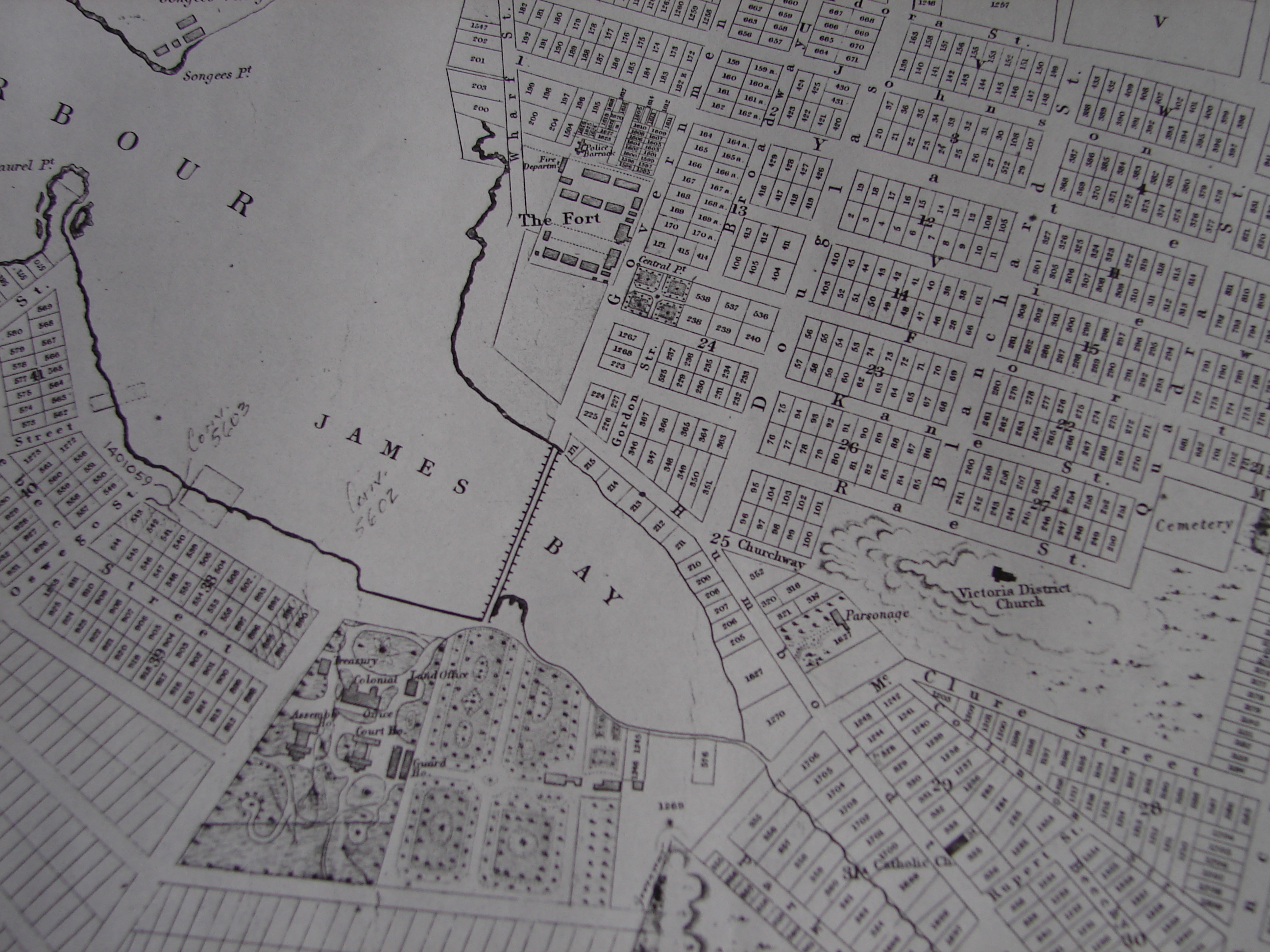
A cadastral map, combined with a
coat of arms, or an imperial insignia could be seen as a powerful
symbol for
the displaying of a state’s or individuals sovereignty over
its
territory (Kain and Baigent 340). The European Empires
coloured
their colonial possessions on world maps as just
such an example of displaying their authority, power and status.
Benedict
Anderson has referred to this phenomenon as
“map-as-logo”
whereby a known map,
(say of an Empire's colonies) could be created and recreated,
“available for
transfer to posters, official seals, letter heads, magazine and
textbook
covers, tablecloths and hotel walls” (Anderson 175).
For
Anderson this processes both aids in the expansion of colonial
nationalism
and anti-colonial nationalism as symbol to rally both around, and
against (Anderson 175).
Thus cadastral maps had political and cultural implication beyond
simply the
administration of property for fiscal reasons.
Back to Top
Colonial Settlement
The reasons for the mass exodus
from Europe to the New World are diverse but the desire for land was
among one
of the preeminent factors that drew the Europeans. As a result the land
that
they took, be it in Ireland or North America, had to be organized into
a system
that was conducive to state administration. Cadastral mapping then was
a key
mechanism for the expansion of colonialism.
In
1858 English surveyors were sent
to Muster Ireland to plan out a new village. It was to be four miles
square and
sub-divided into various sized lots with goal of crating a
“balanced rural
society” (Kain and Baigent 335). In the end
the surveyors were unable to maintain their demarcations which were
resisted by
local residents and the plan at Muster failed for the moment. However,
the use
of cadastral mapping was used again after the 1641 rebellion when
nearly half
of the country was confiscated by the English (Kain and Baigent 335).
Between 1665-1669 the Down Survey created a cadastral map
which
listed all
confiscated lands, reorganizing them into new
“rational”
holdings, and produced
an inventory of the potential use of land into four categories:
cultivable,
bog, mountain, and wood (Kain and Baigent 336). Surveying
then
created both the conditions for the reorganization of domestic
Irish property and land systems into ones that suited the goals and
values of
the colonial administration. In the confiscated areas land was mapped,
its
human population and the potential resources drawn from that land were
more
“legible” for state officials.
Back to Top